
Portal:Western Australia
Introduction Western Australia (commonly abbreviated as WA) is a state of Australia occupying the western third of the land area of Australia, excluding external territories. It is bounded by the Indian Ocean to the north and west, the Southern Ocean to the south, the Northern Territory to the north-east, and South Australia to the south-east. Western Australia is Australia's largest state, with a total land area of 2,527,013 square kilometres (975,685 sq mi). It is the second-largest country subdivision in the world, surpassed only by Russia's Sakha Republic. the state has 2.76 million inhabitants—11 percent of the national total. The vast majority (92 percent) live in the south-west corner; 79 percent of the population lives in the Perth area, leaving the remainder of the state sparsely populated. The first Europeans to visit Western Australia belonged to the Dutch Dirk Hartog expedition, who visited the Western Australian coast in 1616. The first permanent European colony in what is today Western Australia occurred following the landing by Major Edmund Lockyer on 26 December 1826 of an expedition on behalf of the New South Wales colonial government.[text–source integrity?] Lockyer established a convict-supported military garrison at King George III Sound, at present-day Albany, and on 21 January 1827 he formally took possession for the British Crown of the western part of the continent that was not already claimed by the Crown. This was followed by the establishment of the Swan River Colony in 1829, including the site of the present-day capital, Perth. (Full article...)
|


(Northern
Territory) |
 Good articles -
-

Victoria Park railway station is a suburban railway station on the Transperth network in Western Australia. The station is in the Perth suburbs of Lathlain and Victoria Park. Since November 2023, the station has been the terminus of the Armadale and Thornlie lines due to the Victoria Park-Canning Level Crossing Removal Project. The whole of each line is expected to reopen in mid-2025.
The first Victoria Park station opened in 1898 after lobbying by the Municipality of Victoria Park. It gained a station master in 1922, which lasted until 1969. The Victoria Park section of the Armadale line underwent several improvements in the 2000s. Lathlain station closed in 2003, and a nearby level crossing was removed and replaced with a bridge. The Thornlie line commenced services on 7 August 2005, enabling most Armadale services to skip the station. In 2007, construction started on a new Victoria Park station, 230 metres (750 ft) south of the original station and closer to the demolished Lathlain station. The new station had greater accessibility and was no longer on a curve, which allowed for a smaller platform gap. The new Victoria Park station opened on 2 August 2008, and the old one was demolished soon afterwards. (Full article...) -
John Biase D'Orazio (Italian: [ˈbjaːze doˈrattsjo]; 5 September 1955 – 11 April 2011) was an Australian politician who served as the member for Ballajura in the Western Australian Legislative Assembly from 10 February 2001 to 6 September 2008. He was a minister in the governments of Geoff Gallop and Alan Carpenter, and a member of the Australian Labor Party until 29 August 2006, when he resigned following several controversies. Born to Italian immigrants, D'Orazio grew up on a market garden in the Perth suburb of Bayswater. He studied pharmacy at the Western Australian Institute of Technology, later opening his own pharmacy business. In 1981, he was elected to the Bayswater council, and in 1984, he became the mayor of Bayswater, in which position he served until 2001.
At the 2001 Western Australian state election, D'Orazio was elected to the seat of Ballajura in the Western Australian Legislative Assembly, beating the Liberal incumbent Rhonda Parker. Following the 2005 state election, he was promoted to cabinet by Premier Geoff Gallop, becoming the minister for justice and minister for small business. On 3 February 2006, after Alan Carpenter became Premier, D'Orazio was appointed as the minister for police and emergency services, minister for justice, and minister for community safety. (Full article...) -

Aerial view of Fremantle Prison (1935)
The architecture of Fremantle Prison includes the six-hectare (15-acre) site of the former prison on The Terrace, Fremantle, in Western Australia. Limestone was quarried on-site during construction, and the south-western corner (the South Knoll) and eastern portion of the site are at a considerably higher ground level. The Fremantle Prison site includes the prison cell blocks, gatehouse, perimeter walls, cottages, tunnels, and related infrastructure.
The Main Cell Block is the longest and tallest cell range in Australia, and a dominating feature of the prison. New Division, constructed between 1904 and 1907, continues the façade alignment of the main block. Service buildings were converted into the separate Women's Prison. Fremantle Prison is surrounded by limestone perimeter walls, while a two-storey limestone gatehouse, with a central clock, presents an imposing entrance. North and south of the gatehouse, on The Terrace, are several cottages and houses – three of which are built in Victorian style in contrast to the Georgian style of the others. (Full article...) -
Tonkin Highway is an 81-kilometre-long (50 mi) north–south highway and partial freeway in Perth, Western Australia, linking Perth Airport and Kewdale with the city's north-eastern and south-eastern suburbs. As of April 2020, the northern terminus is at the interchange with Brand Highway and Great Northern Highway in Muchea, and the southern terminus is at Thomas Road in Oakford. It forms the entire length of State Route 4, and connects to several major roads. Besides Brand Highway and Great Northern Highway, it also connects to Reid Highway, Great Eastern Highway, Leach Highway, Roe Highway, and Albany Highway.
Planning for the route began in the 1950s, but the first segment between Wattle Grove and Cloverdale was not opened until 1980. Over the next five years, the highway was extended north to Great Eastern Highway and south to Albany Highway, and a discontinuous section was constructed north of the Swan River. In 1988 the Redcliffe Bridge linked these sections, and three years later, Reid Highway became the northern terminus. The next major works on the highway, between 2003 and 2005, extended the highway south to Thomas Road. (Full article...) -
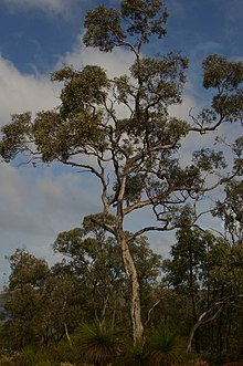
Eucalyptus wandoo, commonly known as wandoo, dooto, warrnt or wornt and sometimes as white gum, is a small to medium-sized tree that is endemic to the southwest of Western Australia. It has smooth bark, lance-shaped adult leaves, flower buds in groups of nine to seventeen, white flowers and conical to cylindrical fruit. It is one of a number of similar Eucalyptus species known as wandoo.
E. wandoo was first described in 1934 by the Australian botanist William Faris Blakely in his book A Key to the Eucalypts using material collected by the English collector Augustus Frederick Oldfield from a sand plain along the Kalgan River. , Plants of the World Online lists Eucalyptus redunca var. elata as a taxonomic synonym of E. wandoo. (Full article...) -
Benjamin John Small (born 11 June 1988) is an Australian politician. He was selected to serve as a senator for Western Australia, representing the Liberal Party, to fill a casual vacancy following Mathias Cormann's resignation. His first term lasted from November 2020 until his April 2022 resignation, and he resumed his term in May after being nominated to replace himself. Small was unsuccessful in his re-election bid in the 2022 federal election and his term as senator concluded on 30 June 2022.
Small studied nautical science, marine operations, and business management. He worked in marine transport and logistics for several energy and resource companies, with his holdings in those criticised as a potential conflict of interest. Before becoming a senator, he was active in grassroots politics, and unsuccessfully attempted to enter parliament at the 2016 election. Ideologically, he was considered a member of the National Right faction of the parliamentary Liberal Party. (Full article...) -
Raymond James O'Connor (6 March 1926 – 25 February 2013) was an Australian politician who served as the premier of Western Australia from 25 January 1982 to 25 February 1983. He was a member of the Parliament of Western Australia from 1959 to 1984, and a minister in the governments of David Brand and Charles Court. O'Connor was born in Perth and attended schools in the Wheatbelt towns of Narrogin and York as well as St Patrick's Boys' School in Perth, leaving school at the age of 14. He competed in athletics and played Australian rules football as a teenager and young adult, including playing 14 matches for East Perth in the Western Australian National Football League. During World War II, he served in the Second Australian Imperial Force in New Britain and Bougainville.
O'Connor joined the Liberal Party in 1957 and was elected to the Western Australian Legislative Assembly in 1959. From 1965 to 1971, he was a minister in the Brand government. During this time, he served as the minister for railways and minister for transport, in which he oversaw the gauge standardisation project of the railway between Perth and Kalgoorlie. He became a minister again when Court was elected premier in 1974. He was police minister when the murder of Shirley Finn occurred in 1975, which remains unsolved but was likely done by a corrupt police officer. (Full article...) -
The Causeway is an arterial traffic crossing in Perth, Western Australia, linking the inner-city suburbs of East Perth and Victoria Park. It is carried over the Swan River at the eastern end of Perth Water by two bridges on either side of Heirisson Island. The current Causeway is the third structure to have been built across the river at this point.
Originally the site of mudflats which restricted river navigation, the Colony Government constructed a causeway and bridge across the site. The project was first planned in 1834 and opened in 1843. When floods in 1862 almost destroyed it, the structure was rebuilt using convict labour, and raised to better withstand future floods. Governor John Hampton officially opened the new Causeway on 12 November 1867. Over the following decades, the three bridges making up this second Causeway were widened several times, and they were eventually replaced in 1952. (Full article...) -
Sherwood railway station (officially Sherwood Station and previously known as Kingsley Station) is a suburban railway station in Armadale, a suburb of Perth, Western Australia. It is on the Armadale line which is part of the Transperth network, and is 28.6 kilometres (17.8 mi) southwest of Perth station and 1.8 kilometres (1.1 mi) north of Armadale station. The station opened in 1973 as Kingsley, but was renamed to Sherwood in 1993. It consists of two side platforms with a pedestrian level crossing. It is not fully accessible due to steep ramps, wide gaps at the pedestrian level crossing, and wide gaps between the platform and train. Services are operated by Transperth Train Operations, a division of the state government's Public Transport Authority. Peak services reach seven trains per hour in each direction, whilst off-peak services are four trains per hour. (Full article...) -
Greenwood railway station is a park and ride suburban railway station in Perth, Western Australia, within the suburbs of Duncraig and Greenwood. The station is on the Joondalup line and is part of the Transperth network. Located within the median strip of the Mitchell Freeway at an interchange with Hepburn Avenue, Greenwood station consists of two side platforms connected to a car park east of the freeway by a footbridge.
The station was included within early plans for the Joondalup line in the 1980s, but the final plan for the Joondalup line, which opened in December 1992, did not include the construction of Greenwood station. After several promises by the state government during the 1990s to build the station, a A$6.8 million contract was awarded to John Holland Group in February 2004 to construct the station. Construction began in March 2004, and the station opened on 29 January 2005, relieving pressure on the car parks at Warwick and Whitfords stations. (Full article...) -
Bedford is a suburb 6 kilometres (4 mi) north-east of the central business district (CBD) of Perth, the capital of Western Australia. Named after Frederick Bedford, the Governor of Western Australia from 1903 to 1909, the suburb is within the City of Bayswater local government area. It is predominantly a low density residential suburb consisting of single-family detached homes, with clusters of commercial buildings along Beaufort Street, Grand Promenade and Walter Road.
Before European settlement, the area was inhabited by the Mooro group of the Whadjuk Noongar people. The first major developments for the suburb occurred in the 1920s, when the extension of Beaufort Street and its associated tram service into the area triggered housing construction. Bedford Park was gazetted as a townsite in 1937, and major growth occurred following World War II, due to developments by the State Housing Commission. Today, Bedford is fully suburbanised. (Full article...) -
Clarkson railway station is a commuter rail station in Clarkson, a suburb of Perth, Western Australia. It is on the Joondalup line, which is part of the Transperth network. Located in the median of the Mitchell Freeway, the station consists of an island platform connected to the west by a pedestrian footbridge. A six stand bus interchange and two carparks are located near the entrance.
Planning for an extension of the Joondalup line north of Currambine railway station was underway by 1995. The government committed to an extension to Clarkson the following year, and a plan detailing the extension was released in 2000. The first contract for the project, a A$14 million earthworks contract, was awarded to Brierty Contractors in March 2001. In April 2002, Barclay Mowlem and Alstom were awarded a contract worth $17 million to design and build the extension's rail infrastructure, and in November 2002, a $8.7 million contract was awarded to Transfield for the construction of the station. The station opened on 4 October 2004, with five new Transperth B-series trains entering service that day. The following day, bus services in the area were realigned to feed into Clarkson station. On 3 September 2013, there was a minor train crash at Clarkson station. On 21 September 2014, an extension of the Joondalup line 7.5 kilometres (4.7 mi) north to Butler railway station was opened. (Full article...) -
Great Northern Highway is an Australian highway that links Western Australia's capital city Perth with its northernmost port, Wyndham. With a length of almost 3,200 kilometres (2,000 mi), it is the longest highway in Australia, with the majority included as part of the Perth Darwin National Highway. The highway, which travels through remote areas of the state, is constructed as a sealed, predominantly two-lane single carriageway, but with some single-lane bridges in the Kimberley. Economically, it provides vital access through the Wheatbelt and Mid West to the resource-rich regions of the Pilbara and Kimberley. In these areas, the key industries of mining, agriculture and pastoral stations, and tourism are all dependent on the highway.
In Perth, the highway begins in Midland near Great Eastern Highway, and further north intersects the Reid and Roe highways, which together form Perth's ring road. There are also three rural highways that spur off Great Northern Highway. Brand Highway and North West Coastal Highway provide an alternative coastal route between Muchea and Port Hedland, while Victoria Highway carries the National Highway route and interstate traffic into the Northern Territory. Various road routes are allocated to sections of Great Northern Highway, including the Highway 1 routes National Route 1 and National Highway 1, as well as National Highway 95. (Full article...) -

Narrows Bridge
The Narrows Bridge is a freeway and railway crossing of the Swan River in Perth, Western Australia.
Made up of two road bridges and a railway bridge constructed at a part of the river known as the Narrows, located between Mill Point and Point Lewis, it connects the Mitchell and Kwinana Freeways, linking the city's northern and southern suburbs. The original road bridge was opened in 1959 and was the largest precast prestressed concrete bridge in the world. Construction of the northern interchange for this bridge necessitated the reclamation of a large amount of land from the river. (Full article...) -
Severe Tropical Cyclone Alby was regarded as the most devastating tropical cyclone to impact southwestern Western Australia on record. Forming out of an area of low pressure on 27 March 1978, Alby steadily developed as it tracked southwestward, parallel to Western Australia. Between 1 and 2 April, the storm quickly intensified and attained its peak intensity as a Category 5 cyclone on the Australian cyclone intensity scale. After turning to the southeast, the storm underwent an extratropical transition as it neared Cape Leeuwin. The storm brushed the cape on 4 April, bringing hurricane-force winds, before rapidly losing its identity the following day.
In Western Australia, the combination of Alby's fast movement and hurricane-force winds caused widespread damage. Along the coast, large swells flooded low-lying areas and numerous homes lost their roofs from high winds. Further inland, bushfires were worsened by the storm as it brought little rain, generally less than 20 mm (0.79 in) along the coast. These fires burned roughly 114,000 hectares (281,700 acres) and destroyed two towns. Five fatalities are attributed to Alby and the associated brushfires. The resulting damage was extensive, with monetary losses reaching A$50 million (US$45 million). (Full article...)

_(cropped).png)


.png)


Did you know (auto-generated)

- ... that Western Australia was the second Australian state to legalise voluntary assisted dying?
- ... that Nick Goiran, a member of the Western Australian Legislative Council, proposed 357 amendments to a voluntary assisted dying bill?
- ... that Bill Dunn, an Indigenous Australian pastoralist approaching retirement, sold his station at half-price to the Jigalong community despite receiving full-price offers from non-Indigenous people?
- ... that the search for a lost radioactive capsule along a 1,400-kilometre (870 mi) stretch of road in Western Australia was likened to looking for a needle in a haystack?
- ... that Mertome Village in Bayswater, Western Australia was the first aged care complex to be built by a local government in Australia?
- ... that politician John D'Orazio helped to secure a three-year trial of daylight saving time in Western Australia?
Categories

More portals
More did you know...

- ...that when the 1987 America's Cup was raced off Fremantle, Western Australia it was the first time for 132 years that the regatta had not been hosted by the New York Yacht Club?
- ...that the original Victoria Dam, constructed in 1891, was the first dam in Western Australia, and it stood for almost 100 years before being replaced with the current dam?
- ...that Anglican bishop Kay Goldsworthy was consecrated as the first woman bishop of any Australian church on 22 May 2008?
Related WikiProjects

Things you can do
Here are some tasks you can do to help with WikiProject Western Australia:
Associated Wikimedia
The following Wikimedia Foundation sister projects provide more on this subject:
-
 Commons
Free media repository -
 Wikibooks
Free textbooks and manuals -
 Wikidata
Free knowledge base -
 Wikinews
Free-content news -
 Wikiquote
Collection of quotations -
 Wikisource
Free-content library -
 Wikispecies
Directory of species -
 Wikiversity
Free learning tools -
 Wikivoyage
Free travel guide -
 Wiktionary
Dictionary and thesaurus


