
Mahan, Iran
Mahan
Persian: ماهان | |
|---|---|
City | |
 Shazdeh Garden, Mahan, by night | |
 Mahan | |
| Coordinates: 30°03′28″N 57°16′45″E / 30.05778°N 57.27917°E[1] | |
| Country | Iran |
| Province | Kerman |
| County | Kerman |
| District | Mahan |
| Population (2016)[2] | |
| • Total | 19,423 |
| Time zone | UTC+3:30 (IRST) |
Mahan (Persian: ماهان, also Romanized as Māhān or Mâhân; also known as Māhūn)[3] is a city in, and the capital of, Mahan District of Kerman County, Kerman province, Iran.[4]
At the 2006 census, its population was 16,787 in 4,138 households.[5] The following census in 2011 counted 17,178 people in 4,707 households.[6] The latest census in 2016 showed a population of 19,423 people in 5,713 households.[2]
Mahan is well known for the tomb of the great Sufi leader Shah Ne'emat Ollah-e-Vali, as well as Shazdeh Garden (Prince Garden).[citation needed]
The tomb of Shah Nur-eddin Nematollah Vali, poet, sage, Sufi and founder of an order of darvishes, has twin minarets covered with turquoise tiles from the bottom up to the cupola. The mausoleum was built by Ahmad Shah Kani; the rest of the building was constructed during the reigns of Shah Abbas I, Mohammad Shah Qajar and Nasser-al-Din Shah. Shah Nematallah Wali spent many years wandering through central Asia perfecting his spiritual gifts before finally settling at Mahan, twenty miles south-east of Kerman, where he passed the last twenty five years of his life. He died in 1431, having founded a Darvish order which continues to be an active spiritual force today. The central domed burial vault at Mahan, completed in 1437 was erected by Ahmad Shah Bahmani, king of the Bahmani Sultanate, and one of Shah Nematallah's most devoted disciples.[citation needed]
-
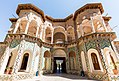 Shazdeh Garden, Mahan. (by day).
 -
 Shah Nematollah Vali Sanctuary.


References[edit]
- ^ OpenStreetMap contributors (30 June 2023). "Mahan, Kerman County" (Map). OpenStreetMap. Retrieved 30 June 2023.
- ^ a b "Census of the Islamic Republic of Iran, 1395 (2016)". AMAR (in Persian). The Statistical Center of Iran. p. 08. Archived from the original (Excel) on 20 October 2020. Retrieved 19 December 2022.
- ^ Mahan, Iran can be found at GEOnet Names Server, at this link, by opening the Advanced Search box, entering "-3073419" in the "Unique Feature Id" form, and clicking on "Search Database".
- ^ Habibi, Hassan (21 June 1369). "Approval of the organization and chain of citizenship of the elements and units of the national divisions of Kerman province, centered in the city of Kerman". Lamtakam (in Persian). Ministry of Interior, Defense Political Commission of the Government Council. Archived from the original on 30 January 2024. Retrieved 30 January 2024.
- ^ "Census of the Islamic Republic of Iran, 1385 (2006)". AMAR (in Persian). The Statistical Center of Iran. p. 08. Archived from the original (Excel) on 20 September 2011. Retrieved 25 September 2022.
- ^ "Census of the Islamic Republic of Iran, 1390 (2011)". Syracuse University (in Persian). The Statistical Center of Iran. p. 08. Archived from the original (Excel) on 29 March 2023. Retrieved 19 December 2022.
External links[edit]
- Photographs of Mahan:
| Authority control databases: Geographic |
|---|
Kerman province, Iran | ||
|---|---|---|
| Capital |  | |
| Counties and cities | ||
| Sights |
| |
| Places | ||
This Kerman County location article is a stub. You can help Wikipedia by expanding it. |