
File:Writing systems worldwide.svg

Size of this PNG preview of this SVG file: 800 × 406 pixels. Other resolutions: 320 × 162 pixels | 640 × 325 pixels | 1,024 × 520 pixels | 1,280 × 650 pixels | 2,560 × 1,300 pixels | 2,754 × 1,398 pixels.
Original file (SVG file, nominally 2,754 × 1,398 pixels, file size: 1.19 MB)
| This is a file from the Wikimedia Commons. Information from its description page there is shown below. Commons is a freely licensed media file repository. You can help. |
Summary
| Description |
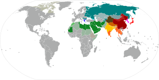
Principal writing scripts worldwide at the national level, with provincial-level scripts in certain cases. Abjads (Green) Arabic Hebrew
Abugidas (Orange and yellow) Northern Brahmic Southern Brahmic Canadian syllabics Geʽez Thaana
Alphabets (Blue and cyan) Armenian Cyrillic Georgian Greek Latin Mongolian Neo-Tifinagh Osage
Syllabaries (Purple) Cherokee
Logographies (Red) Hanzi
Hybrids and combinations (Pink) Japanese (Logographic kanji and syllabic kana) Korean (Alphabetic and syllabic Hangul, with limited use of logographic Hanja) |
| Date | |
| Source | Own work based on: Writing systems worldwide.png, BlankMap-World6.svg and Blank Map World Secondary Political Divisions.svg |
| Author | User:Quintucket, based on work by User:Canuckguy and others. |
| SVG development |

Licensing
I, the copyright holder of this work, hereby publish it under the following licenses:

|
Permission is granted to copy, distribute and/or modify this document under the terms of the GNU Free Documentation License, Version 1.2 or any later version published by the Free Software Foundation; with no Invariant Sections, no Front-Cover Texts, and no Back-Cover Texts. A copy of the license is included in the section entitled GNU Free Documentation License. |
This file is licensed under the Creative Commons Attribution-Share Alike 3.0 Unported license.
- You are free:
- to share – to copy, distribute and transmit the work
- to remix – to adapt the work
- Under the following conditions:
- attribution – You must give appropriate credit, provide a link to the license, and indicate if changes were made. You may do so in any reasonable manner, but not in any way that suggests the licensor endorses you or your use.
- share alike – If you remix, transform, or build upon the material, you must distribute your contributions under the same or compatible license as the original.
You may select the license of your choice.
File history
Click on a date/time to view the file as it appeared at that time.
| Date/Time | Thumbnail | Dimensions | User | Comment | |
|---|---|---|---|---|---|
| current | 03:36, 16 May 2024 | | 2,754 × 1,398 (1.19 MB) | Rubýñ | More color changes. I think I nailed it now |
| 01:39, 16 May 2024 |  | 2,754 × 1,398 (1.19 MB) | Rubýñ | Probably my worst idea yet. I've reverted some of the Alphabet colors. | |
| 00:48, 16 May 2024 |  | 2,754 × 1,398 (1.19 MB) | Rubýñ | Changed Cherokee indigo to purple (was too close to cyrillic blue imo) | |
| 00:45, 16 May 2024 |  | 2,754 × 1,398 (1.19 MB) | Rubýñ | Added Cherokee and Osage, and changed Serbia to Cyrillic-Latin striped (see talk page for requests for both), but the new scripts are making the color legend unwieldy imo. I've changed all colors to hopefully make the map a) more colorblind-friendly and b) group classes of scripts together (abjads are green, alphabets are blue, etc.) I'll change the colors on all legends that use this map ASAP. If anyone can change the Cherokee and Osage dots for the actual borders of Cherokee and Osage natio... | |
| 18:24, 13 July 2023 |  | 2,754 × 1,398 (1.19 MB) | M.Bitton | Added Inuit_Nunangat (per request on the Graphics Lab/Map workshop) | |
| 16:52, 27 June 2023 |  | 2,754 × 1,398 (1.11 MB) | Rubýñ | Hid Antarctica | |
| 16:48, 27 June 2023 |  | 2,754 × 1,398 (1.11 MB) | Rubýñ | Corrected IN-JK and the color of grey stripes | |
| 16:39, 27 June 2023 |  | 2,754 × 1,398 (1.11 MB) | Rubýñ | Added Guangxi. Swapped dots in India for states and territories. Removed Cyrillic from Inner Mongolia. Removed Artsakh | |
| 18:10, 26 June 2023 |  | 2,754 × 1,398 (1.05 MB) | Rubýñ | +Abkhazia and Northern Cyprus | |
| 17:49, 26 June 2023 |  | 2,754 × 1,398 (1.05 MB) | Rubýñ | Corrected countries like Pakistan and Ethiopia that have more than one script. Added Xinjiang, Tibet, and Inner Mongolia. Added Mongolian script and Tifinagh. Changed color of Armenian. Added Northern Brahmic to Fiji for Fiji Hindi. |
File usage
The following pages on the English Wikipedia use this file (pages on other projects are not listed):
Global file usage
The following other wikis use this file:
- Usage on as.wikipedia.org
- Usage on es.wikipedia.org
- Usage on ka.wikipedia.org
- Usage on ms.wikipedia.org
- Usage on simple.wikipedia.org
- Usage on vi.wikipedia.org
- Usage on zh-min-nan.wikipedia.org