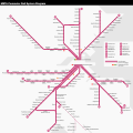
File:MBTA Commuter Rail Map.svg

Size of this PNG preview of this SVG file: 600 × 600 pixels. Other resolutions: 240 × 240 pixels | 480 × 480 pixels | 768 × 768 pixels | 1,024 × 1,024 pixels | 2,048 × 2,048 pixels | 1,760 × 1,760 pixels.
Original file (SVG file, nominally 1,760 × 1,760 pixels, file size: 2.7 MB)
File history
Click on a date/time to view the file as it appeared at that time.
| Date/Time | Thumbnail | Dimensions | User | Comment | |
|---|---|---|---|---|---|
| current | 18:25, 20 May 2024 |  | 1,760 × 1,760 (2.7 MB) | Pi.1415926535 | Update for 5/20 service changes: South Attleboro open, Readville now served by P/S Line |
| 05:02, 18 December 2023 |  | 1,760 × 1,760 (2.7 MB) | Pi.1415926535 | Lynn reopened | |
| 06:24, 23 January 2023 |  | 1,760 × 1,760 (2.7 MB) | Pi.1415926535 | various changes for clarity; P/CF open | |
| 03:03, 23 October 2022 |  | 1,760 × 1,760 (2.71 MB) | Pi.1415926535 | separate Old Colony Lines | |
| 06:58, 6 October 2022 |  | 1,760 × 1,760 (2.7 MB) | Pi.1415926535 | Update: South Coast Rail alignment, Oak Grove, closed stations, station names, etc | |
| 19:57, 14 March 2020 |  | 1,760 × 1,760 (2.6 MB) | Pi.1415926535 | Actually update for Foxboro service; SCR stations still need name fixes | |
| 15:19, 14 March 2020 |  | 1,760 × 1,760 (2.6 MB) | Simtropolitan | Removed old date in upper right corner; map has been continuously updated | |
| 06:50, 26 February 2019 |  | 1,760 × 1,760 (2.6 MB) | Pi.1415926535 | Update Fairmount Line stations; add Silver Line dot at Chelsea | |
| 15:39, 1 August 2017 |  | 1,760 × 1,760 (2.66 MB) | Simtropolitan | Boston Landing added | |
| 00:43, 24 November 2016 |  | 1,650 × 1,650 (2.47 MB) | Pi.1415926535 | Temporary version (still needs other fixes) for Wachusett opening |
File usage
The following pages on the English Wikipedia use this file (pages on other projects are not listed):
Global file usage
The following other wikis use this file:
- Usage on es.wikipedia.org
- Usage on id.wikipedia.org
- Usage on it.wikipedia.org
- Usage on ko.wikipedia.org
- Usage on www.wikidata.org
- Usage on zh-yue.wikipedia.org
- Usage on zh.wikipedia.org

