
File:Bithangol Abbas 2.jpg

Size of this preview: 800 × 600 pixels. Other resolutions: 320 × 240 pixels | 640 × 480 pixels | 1,024 × 768 pixels | 1,280 × 960 pixels | 2,560 × 1,920 pixels | 3,456 × 2,592 pixels.
Original file (3,456 × 2,592 pixels, file size: 3.69 MB, MIME type: image/jpeg)
| This is a file from the Wikimedia Commons. Information from its description page there is shown below. Commons is a freely licensed media file repository. You can help. |
Summary
| Description |
বাংলা: বিথাঙ্গল বড় আখড়া। কীভাবে যাওয়া যায়: শুকনো মৌসুমে হবিগঞ্জ কামড়াপুর ব্রীজ হতে জিপযোগে সুজাতপুর হয়ে নৌকোযোগে অথবা পায়ে হেটে। বর্ষা মৌসুমে হবিগঞ্জ কালার ডুবা থেকে নৌকাযোগে অথবা বানিয়াচং আদর্শবাজার হতে নৌকাযোগে।
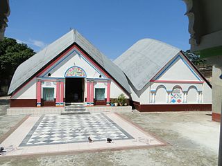
English: Bithangol Bora Akhra is a sacred gymnasium for the Hindu Vaishnava community located about 1 km southwest of Baniachang Sadar Upazila on the bank of the haor. Ramakrishna Goswami founded it in sixteenth century after completing his visit to different holy places of the sub-continent. There are 120 rooms for 120 Vaishnava monastics in thr Akhra. About five hundred years ago, the king of Tripura Uccabananda Bahadur built two buildings in the Akhra. A modern architectural style building has been built on the on the cemetery of the founder. On the last day of the month of Bangla month of Kartik, a hallelujah is celebrated on the occasion of 'Bhola Sankranti'. During the full moon days of Bangla month of Falgun, on the fifth day, 'Dol' festival is celebrated. During Bangla month of Chaitra, on the 8th lunar day, the devotees take holy bath in the River Vera Mohona and the 'Baruni Fair' sits on the bathing quay. Besides, 'Rath Yatra' is held in the 2nd week of the Bangla month of Ashara. In each festival, around 5 to 10 thousand devotees gather. The spectaculars of the Bithangol Akhra are a marble bedstead of 25 mound weight, a bronze throne, a chariot rich in ancient artistry, a bird made of silver and a gold crown.
|
||
| Date | Taken on 15 September 2016, 01:19:11 | ||
| Source | Own work | ||
| Author | Abbas Tarafder | ||
| Other versions |
.jpg)
| Camera location | | View this and other nearby images on: OpenStreetMap |
|---|
Licensing
I, the copyright holder of this work, hereby publish it under the following license:
This file is licensed under the Creative Commons Attribution-Share Alike 4.0 International license.
- You are free:
- to share – to copy, distribute and transmit the work
- to remix – to adapt the work
- Under the following conditions:
- attribution – You must give appropriate credit, provide a link to the license, and indicate if changes were made. You may do so in any reasonable manner, but not in any way that suggests the licensor endorses you or your use.
- share alike – If you remix, transform, or build upon the material, you must distribute your contributions under the same or compatible license as the original.

|
This image was uploaded as part of Wiki Loves Monuments 2016.
|
 |
File history
Click on a date/time to view the file as it appeared at that time.
| Date/Time | Thumbnail | Dimensions | User | Comment | |
|---|---|---|---|---|---|
| current | 20:55, 19 September 2016 | | 3,456 × 2,592 (3.69 MB) | Abbas Tarafder | User created page with UploadWizard |
File usage
The following pages on the English Wikipedia use this file (pages on other projects are not listed):
Global file usage
The following other wikis use this file:
- Usage on bn.wikipedia.org
- Usage on www.wikidata.org