
File:Bassin-fluvial-de-l-Ob.png

Size of this preview: 468 × 600 pixels. Other resolutions: 187 × 240 pixels | 375 × 480 pixels | 599 × 768 pixels | 799 × 1,024 pixels | 1,533 × 1,964 pixels.
Original file (1,533 × 1,964 pixels, file size: 388 KB, MIME type: image/png)
| This is a file from the Wikimedia Commons. Information from its description page there is shown below. Commons is a freely licensed media file repository. You can help. |
Summary
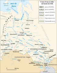
| Description | Bassin fluvial de l'Ob, Russie |
| Date | |
| Source | Own work |
| Author | Pline |
Licensing
I, the copyright holder of this work, hereby publish it under the following licenses:

|
Permission is granted to copy, distribute and/or modify this document under the terms of the GNU Free Documentation License, Version 1.2 or any later version published by the Free Software Foundation; with no Invariant Sections, no Front-Cover Texts, and no Back-Cover Texts. A copy of the license is included in the section entitled GNU Free Documentation License. |
This file is licensed under the Creative Commons Attribution-Share Alike 3.0 Unported, 2.5 Generic, 2.0 Generic and 1.0 Generic license.
- You are free:
- to share – to copy, distribute and transmit the work
- to remix – to adapt the work
- Under the following conditions:
- attribution – You must give appropriate credit, provide a link to the license, and indicate if changes were made. You may do so in any reasonable manner, but not in any way that suggests the licensor endorses you or your use.
- share alike – If you remix, transform, or build upon the material, you must distribute your contributions under the same or compatible license as the original.
You may select the license of your choice.
File history
Click on a date/time to view the file as it appeared at that time.
| Date/Time | Thumbnail | Dimensions | User | Comment | |
|---|---|---|---|---|---|
| current | 09:27, 24 June 2018 | | 1,533 × 1,964 (388 KB) | Pline | Couleurs renforcées, petits déplacements des légendes |
| 11:59, 11 March 2010 |  | 1,533 × 1,964 (184 KB) | Pline | salékhard capitale régionale | |
| 11:47, 11 March 2010 |  | 1,533 × 1,964 (183 KB) | Pline | correction capitale régionale | |
| 18:10, 17 March 2008 |  | 1,533 × 1,964 (183 KB) | Pline | {{Information |Description=Bassin fluvial de l'Ob, Russie |Source=travail personnel |Date=16 mars 2008 |Author= Pline |Permission= |other_versions= }} Category:Maps of Russia |
File usage
The following pages on the English Wikipedia use this file (pages on other projects are not listed):
Global file usage
The following other wikis use this file:
- Usage on ar.wikipedia.org
- Usage on arz.wikipedia.org
- Usage on ast.wikipedia.org
- Usage on azb.wikipedia.org
- Usage on be.wikipedia.org
- Usage on ca.wikipedia.org
- Usage on ceb.wikipedia.org
- Usage on cy.wikipedia.org
- Usage on de.wikipedia.org
- Usage on es.wikipedia.org
View more global usage of this file.